22 March 2014, 0900-1000 hrs NZDT
TIDE: 8:23 am low (0.6 m), 14:44 pm high (2.9 m)
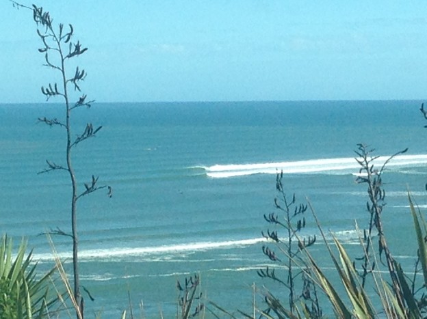
Just before 9 am NZDT March 22, 2014, I was at the Michael Hope Lookout over Ngaranui Beach. I was watching the swell break over the Raglan Bar. The swell was very clean with an easterly wind. Low tide according to the MetService was 0.6 m at 8:23 am. Two boats were anchored well clear of the south side of The Bar, and there were a handful of surfers plus three stand up paddle-boarders catching well formed right handers breaking there. I also noticed some very fast, clean left-handers breaking along the northern flank of The Bar.
My friend Ed Atkin, who is also a member of the local volunteer Raglan Coastguard (RCG), drove up and parked next to me as we watched the waves. At that time, we noticed a fishing boat trying to get out across the bar. The boat was trying to traverse the northern flank (the left hander). When we first noticed the boat, it was facing in towards the Harbour, like it had tried to cross and turned back. It then turned back around and tried to head out during a lull in the swells.
As it crossed, I could see a wave peeling down the sand bank towards the boat, it was not one of the bigger waves that day. That first wave hit the boat as a bore (whitewater) and the vessel stayed upright but lost all forward speed. It started moving again, trying to make it across as another, slightly larger wave was breaking down the bank. This wave broke just outside of the boat’s position and hit the boat nearly immediately afterward. The boat was capsized and several people could be seen in the water.
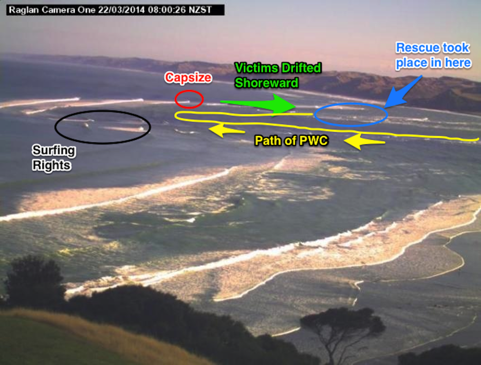
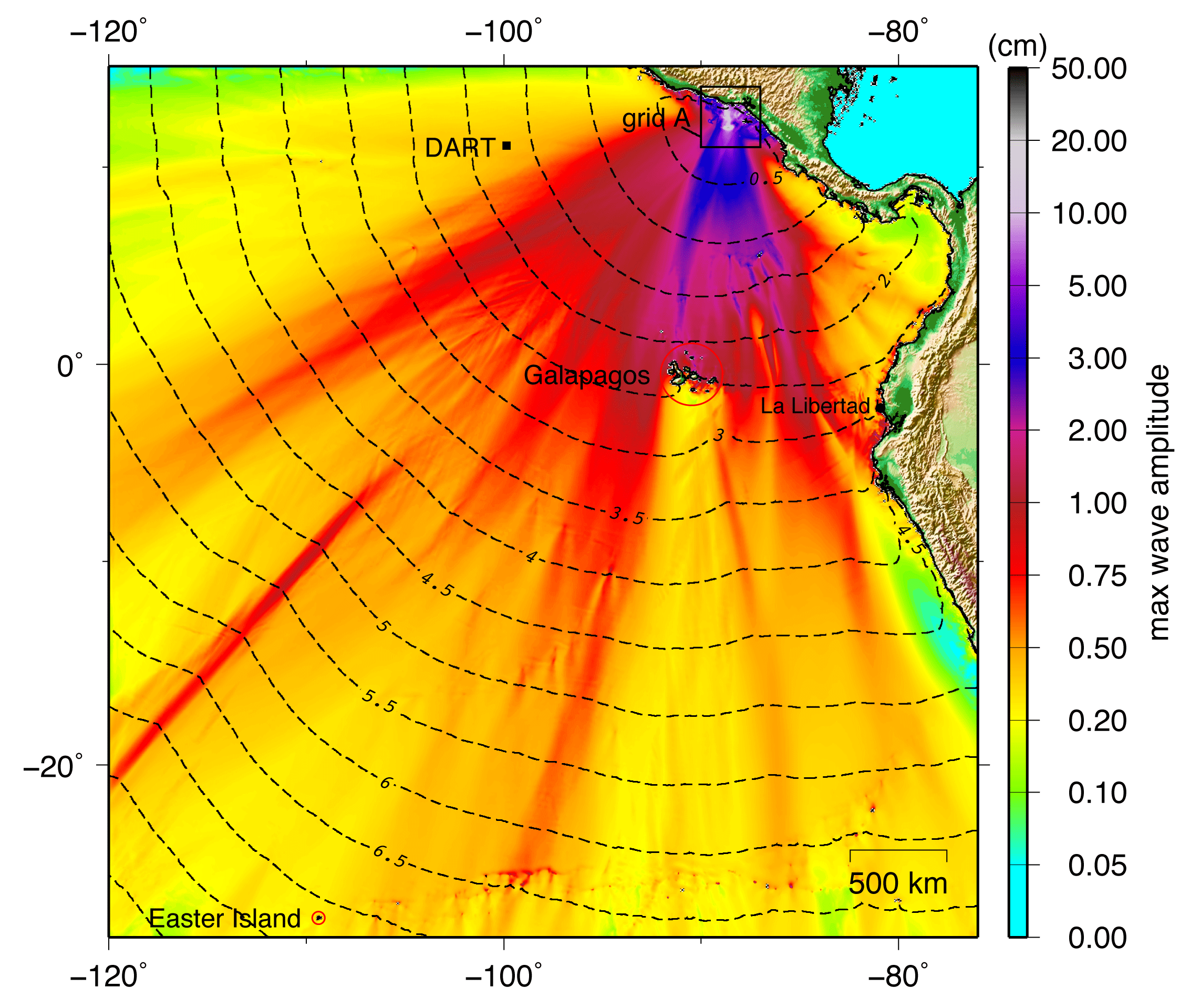
The image above shows a snapshot of the Raglan Bar taken this morning at 8 am by the NIWA cam-era system. This was approximately 1 hr before the incident. I have superimposed the approximate location of where things happened.
Ed immediately called his colleagues at the Coastguard and departed to go to the station at the Raglan Wharf and take part in the rescue. I stayed at the lookout to maintain visual contact with the boat and the victims.
In a very short amount of time, the boat and the cluster of victims were separated by 10’s of meters. The victims appeared to be staying together. At first I thought there were 5 or 6 people, but later it seemed there were only 4. However, I am not entirely sure. The current was pushing them along the shallows just inside the northern flank of The Bar. I started my stopwatch about 5 minutes after the event to keep track of time as things unfolded.
Approximately 20 minutes after they capsized, I first noted the Raglan Coastguard’s (RCG) Personal Water Craft (PWC) coming out of the harbor entrance. They sped out towards the location where the boat capsized, but apparently could not see the boat or victims since they passed by them. The PWC reached the approximate location where the boat capsized and turned to the right, following the current and the wave breaker line shoreward. They quickly made visual contact with the boat, and then the victims. The PWC reached the victims ~25 minutes after the boat capsized.
During this, I noted the Surf Lifesaving (SL) speedboat being towed along the beach by a quad-bike, heading toward the harbor entrance to launch from flat water and assist in the rescue. Also, the larger Coastguard boat was by now also just making its way out of the harbor entrance.
The PWC appeared to pick up two victims and was heading across in towards the center of the main harbor channel as the larger coastguard boat headed in along the main channel towards their location.
Both the larger Coastguard vessel and the Surf Lifesaving speedboat initially went out past the location of the victims and turned around. As the PWC was coming in to meet the CG boat, the Surf Lifesaving speedboat had gotten approximately to the capsize location and turned around, following the breaker line shoreward. They quickly made contact with the capsized vessel and then with the victims. The SL speedboat reached the remaining victims as the PWC was returning to that location.
At this time the large Coastguard vessel was motoring in towards the entrance of the harbor, the PWC and the speedboat were next to each other. The PWC departed towards the large Coastguard vessel as the speedboat continued shoreward in the shallows. The victims appeared to be on the SL Speedboat.
All of the vessels then gathered at the entrance to the harbor. At this time I lost visual contact with the action as the flotilla drifted into the harbor and out of my line of sight. This was ~40 minutes after the initial incident.