Reports have come up on tsunami related discussion boards that a possible ‘Meteo Tsunami’ occurred back on June 13, 2013 and was observed and measured across the Atlantic Ocean. The impressive account of the wave’s effects in New Jersey was reported by Dr. Paul Whitmore of the West-Coast Alaska Tsunami Waring Center (WCATWC) and is pasted below.
Apparently, on an otherwise flat day, the waters in Barnegat Inlet in New Jersey suddenly withdrew much faster than the normal out going tide. The water returned as a one-wave surge on the order of 6 feet peak to trough which broke all the way across the inlet. It swept people off the rocks causing some injuries. The wave was also recorded on tide gauges in Bermuda and Puerto Rico.

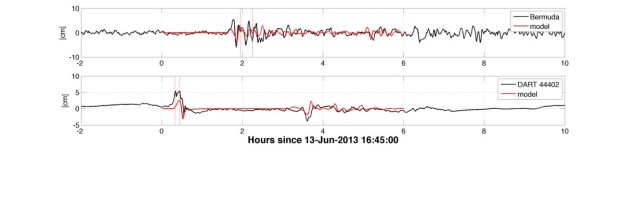
Figure: modelling and measurements of the tsunami from NOAA/PMEL. The top trace is the recording in Bermuda and the lower trace is the recording on the DART tsunami measuring buoy in the Atlantic.)
If it was a ‘Meteo Tsunami’, that in itself is interesting. These are relatively rare waves caused when a low pressure area moves rapidly across the water surface, causing the water to move up and down and generating a wave. One such wave was observed in Daytona Beach Florida on the night of July 3, 1992. The surge washed over the dunes and swamped several police cars that were out on the beach that night. [read more here: link1 (weather blog post) and link2 (Reference to a journal article)]
What is even more interesting is that now scientists from the tsunami group at the Pacific Marine Environmental Laboratory have some evidence suggesting that the wave may have been generated by an underwater landslide in the Hudson Canyon off of the New York/New Jersey border.
Recall that the horrible 1998 Papua New Guinea tsunami was caused by a not-that-large (4 cubic km) landslide off shore of Aitape and that there was only a very small earthquake that likely triggered the landslide. Landslide tsunami are worrisome in that they have the potential to cause huge destruction in very isolated areas with basically no natural warning. Furthermore, so little is known about the details of underwater landslides (i.e. how frequently they happen, how they move, how big they can be) we know almost nothing about their tsunamigenic potential.
=====================================================
Tsunami-like waves were observed along the US east coast during the afternoon of Thursday, June 13, 2013. Over 30 tide gages recorded the fluctuations with impacts noted along the New Jersey shore and in Massachusetts. In Barnegat Light, NJ, at least two people were swept off a breakwater and required medical treatment . Brian Coen who was spearfishing near the mouth of the bay reported the following:
Around 3:30pm on Thursday June 13, 2013, Brian Coen was spearfishing near the mouth of Barnegat Inlet; just south of the submerged northern breakwater. Earlier in the day around noon, thunderstorms had moved through the area. By 3:30pm the weather was overcast with a light east wind. At approximately 3:30, the outgoing tide was amplified by strong currents which carried divers over the submerged breakwater (normally 3-4 feet deep). This strong outrush continued for 1-2 minutes and eventually the rocks in the submerged breakwater were exposed. Brian backed his boat out before being sucked over as well.
At this point, Brian noticed a large wave coming in, approximately 6 feet peak-to-trough and spanning across the inlet. The upper 2 feet of the wave was breaking. This wave occurred in conjunction with a reversal of the current such that even though the tide was going out, a strong surge was entering the inlet. This surge carried the divers back over the submerged reef and into the inlet from where they were picked up. On the south jetty three people were swept off the rocks which were 5 to 6 feet above sea level at the time. At least two were injured requiring medical treatment. There was no more strong activity after about 5 minutes.
Impacts were also noted in southern MA
(http://www.capecodonline.com/apps/pbcs.dll/article?AID=%2F20130615%2FNEWS%2F306150317%2F-1%2FNEWS01).
The NOAA DART buoy 44402 located just east of the continental slope off New Jersey picked up the event and put the DART in trigger mode. Further, waves were observed on the Bermuda tide gage and some Puerto Rico tide gages which match the expected time of arrival from a source east of New Jersey. Several gages in Chesapeake Bay recorded the event; some showed two different events about 7 hours apart.
The event occurred in close conjunction with a strong weather system moving from west to east off the New Jersey coast which is labeled by the NWS as a low-end derecho. Air pressure recordings from taken from NOS sites (6 minute samples) indicate strong pressure fluctuations near the time of the event. At sites in Delaware and southern NJ (Cape May), the tide gage observations are nearly coincident with the pressure fluctuation, while at other sites the relationship is not as clear. A summary of the pressure recordings is attached (thank you Yoo Yin Kim).
This may be the first meteotsunami recorded at trans-oceanic distances (at least that I’ve heard of) if it holds up that the Bermuda and Puerto Rico observations are directly related to the event and the source is shown to be wholly due to meteorological sources.
WCATWC will post a summary site containing the tide gage data next week at http://oldwcatwc.arh.noaa.gov/about/tsunamimain.php.
Paul Whitmore
NOAA/NWS West Coast and Alaska Tsunami Warning Center
=====================================================