Solomon Islands Tsunami 2013

Yesterday (February 6th, 2013) there was a Magnitude 8.1 earthquake in the Solomon Islands. The southwest Pacific was put on a tsunami alert, with a few places in ‘warnings’ and others in ‘watch’. New Zealand was in a ‘watch’. I did a bit of modeling during the day in support of the information the New Zealand Tsunami Experts Panel (TEP) was providing to New Zealand Civil Defense.
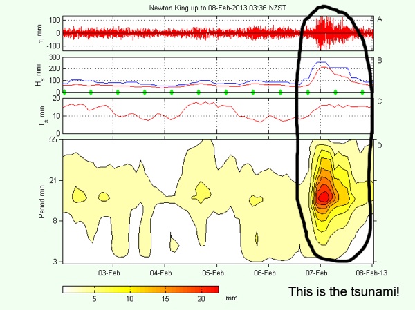
The figure above shows the maximum tsunami wave heights across the SW Pacific and the Tasman Sea. Between what we already knew about the size of the earthquake and tsunamis from this region, plus some of the modeling, it was apparent that there was no real danger to New Zealand. Tsunami waves did arrive in the evening on February 6th and peaked around midnight, this also coincided with low tide. Peak wave amplitudes were about 14 cm at Port Taranaki in New Plymouth. You can see an interesting real-time analysis of long wave surges at Port Taranaki on Dr. Derek Goring’s Port Taranaki page. The figure below is from that site, it very clearly shows the tsunami energy arriving at levels well above the background noise. I have circled the tsunami signal so it is even more obvious!
Thursday, 7 February 2013
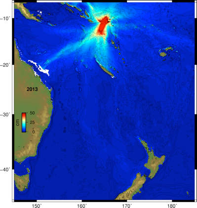
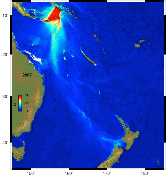
Looking back at the image at the top of the page, you can see that the wave energy was pushed into northern New Caledonia and mostly blocked from the Tasman Sea. This is different than what happened in 2007, when a similar sized earthquake occurred about 500 km further west near Gizo in the Solomon Islands. This event caused maximum wave heights at Port Taranaki that were about twice as large as what happened yesterday (but still quite small, and did not cause any damage). I also ran a model simulating the 2007 event to make a comparison, you can see it in the image below (Figure 2).
Note how the wave energy is tracked into the west coast of New Zealand, interesting, no? This is called a ‘wave guide’ and is an important feature of trans-oceanic tsunami propagation and is a major factor in why places like Crescent City, California get more frequently damaged by tsunamis.
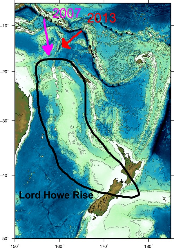
For this particular case I have included a little cartoon in my last figure (Figure 3) that shows the location of the Lord Howe Rise, which is the bathymetric feature that caused the wave energy to be focussed into the west coast of new Zealand. During the February 6th, 2013 event, the tsunami source was too far to the east to efficiently push energy on to that feature. It was a little more favorable in 2007. What west coast New Zealand really has to worry about as far as tsunamis goes is a ‘really big’ earthquake (like 8.5 or larger) on the section of the fault just to the east of the 2007 earthquake. If/when this one happens, we will see significant surges and possible inundation of low lying areas along the west coast of both islands of New Zealand.
FIGURE 1. The tsunami as it was recorded in Port Taranaki (image courtesy of Dr. Derek Goring, http://www.mulgor.co.nz)
FIGURE 2. Maximum tsunami wave heights across the SW pacific and Tasman Sea for the 2007 Solomon Islands (‘Gizo’) earthquake and tsunami. This earthquake was roughly the same size as the 2013 event, but more favorably located to send wave energy to New Zealand.
FIGURE 3. A cartoon showing the location of the Lord Howe Rise relative to the two most recent earthquake and tsunami source from the Solomon Islands.
Questions? Comments? Contact me, Jose C. Borrero: ecoast.co.nz or jocabo.net