Tsunami: August 26, 2012 in El Salvador, Preliminary Findings

Last week I co-led a post event field survey investigating the effects of a tsunami generated by a magnitude 7.3 (USGS) earthquake which occurred on August 26th, 2012 off the coast of El Salvador.
After hearing reports of inundation and some other effects, we started a collaboration with the International Tsunami Information Center (ITIC) and the El Salvadorean Ministry of the Environment and Natural Resources (MARN) to conduct a field survey of the affected area. The survey was co-led by myself and Professor Hermann Fritz of the Georgia Institute of Technology. We travelled to San Salvador on September 3, met with the MARN staff on the 4th and worked in the field on the 5th and 6th. Besides measuring the tsunami and documenting its effects, we also provided technical assistance and training to MARN in the form of tsunami field surveying techniques and damage assessment.
The bottom line was that the tsunami affected approximately 40 km of coastline and reached a height of some 5 to 6 m above sea level in the most affected area, inundating up to 300 m inland. Fortunately, the most affected area was largely unpopulated and there were no deaths or major structural damage. There were however several injuries, some of them serious. The earthquake occurred at 10:37 pm local time and the tsunami affected the coast some 30 minutes afterwards. At that time there were approximately 300 people on the affected coastline collecting sea turtle eggs for sea turtle conservation programs going on in that area. Many of the people on the beach were swept away and washed some 100 m inland. A few people suffered broken bones and everyone was very, very scared.
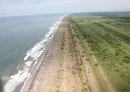
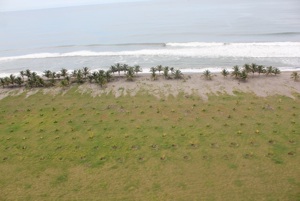
The picture above shows the extent of the inundation, you can see the browning of the grass where the saltwater penetration is causing the grass to die off. You can also see how undeveloped this part of the coastline is. The story is much different just 30 km to the west where the region of Costa Del Sol, and its beach front houses, hotels and restaurants sit very close to shore. Luckily this tsunami only affected a small part of the coastline and there were no serious effects at Costa del Sol.
A pdf of the field survey preliminary results (IN SPANISH) can be found HERE.
LINK to the MARN story and press release.
The interesting detail is that this was a 'SLOW' earthquake, one that releases its seismic energy slower than normal and is therefore more efficient in generating a tsunami. This earthquake was a magnitude ~7.3, and 'standard' tsunami generation models would only predict and tsunami on the order of 1-2 m. However, the tsunami here was over 5 m and inundated up to 300 m inland. The other scary/strange feature of these types of earthquakes is that due to the slow energy release, sometimes people in the source region do not feel the ground shaking, or if they do, it is of a gentle rocking nature and one that does not cause alarm or trigger the 'run for the hills, tsunami is coming' response.
Other recent examples of slow earthquakes and tsunamis are:
• September 1992 Nicaragua tsunami (effecting the surf region of El Popoyo) and killing 170 locals
• September 1994 East Java tsunami and earthquake that overran the G-Land surf camps
• July 2006 earthquake in West Java that caused a tsunami killing more than 600 people near Nusa Pangandaran and Cilacap, West Java
• October 2010 Mentawai tsunami off of the Pagai Islands that killed approximately 500 people, took out the Macaronis surf camp and the charter boat Midas while nearly taking out the Freedom 4 charter boat.
• August 2012 El Salvador, 5-6 m tsunami, and 300 m inundation, but no deaths or damage beacause the affected area was undeveloped. People on the beach that night were washed away and some were seriously injured.
A few photos from the survey are presented below.
Tuesday, 11 September 2012
Flow depth here was 2.3 m above ground.
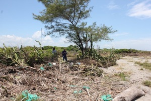
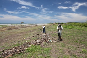
Evidence of inundation.
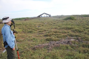
Prof. Fritz at a tsunami debris line.
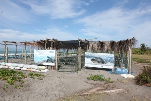
A turtle hatchery rebuilt since the tsunami.
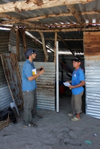
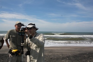
Prof. Fritz training MARN scientists on the surveying equipment.
A very clear debris line.
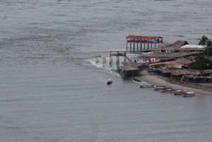
La Puntilla at the eastern end of Costa del Sol, no damaging tsunami effects were observed or reported here.
Evidence of tsunami overwash.