Introduction

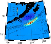
The work presented here describes the hydrodynamic numerical modeling of tsunami induced effects at several sites along the Southern California coast. This modeling study is conducted in support of the US Geological Survey’s Multi-Hazards Demonstration Project SAFRR: Science Application for Risk Reduction. The objective of this study is to describe in detail, and using the best available science, the effects of a hypothetical, but possible, large tsunami generated by a magnitude 9.0 earthquake in the eastern Aleutian Islands. The results will be used by researchers to better understand and prepare for natural disasters and will also be disseminated through a wide variety of media outlets and formats as educational material and experiences for the public.
The earthquake is defined to occur at 11:50 am PDT (10:50 am Alaska time) on Thursday, March 27th, 2014, the 50th anniversary of the great 1964 Alaska earthquake which generated California’s most destructive tsunami in recorded history. The simulations presented here will be used to help educate emergency responders as well as port officials and engineers to better understand the potential impact of this type of event. Use the links at the top of the page or below to
Countdown to the 50th Anniversary of the 1964 Gulf of Alaska earthquake and tsunami
Numerical Modeling by Jose C. Borrero, eCoast Consulting, Raglan, New Zealand
UPDATED: Tuesday December 11, 14:00 PST